Weather stations across North Georgia have had quite the busy year. The station in Cornelia had already exceeded the yearly rainfall average by 1″ before the end of October and seemed poised to crack the top ten wettest on record.
Then something strange happened; things dried up.
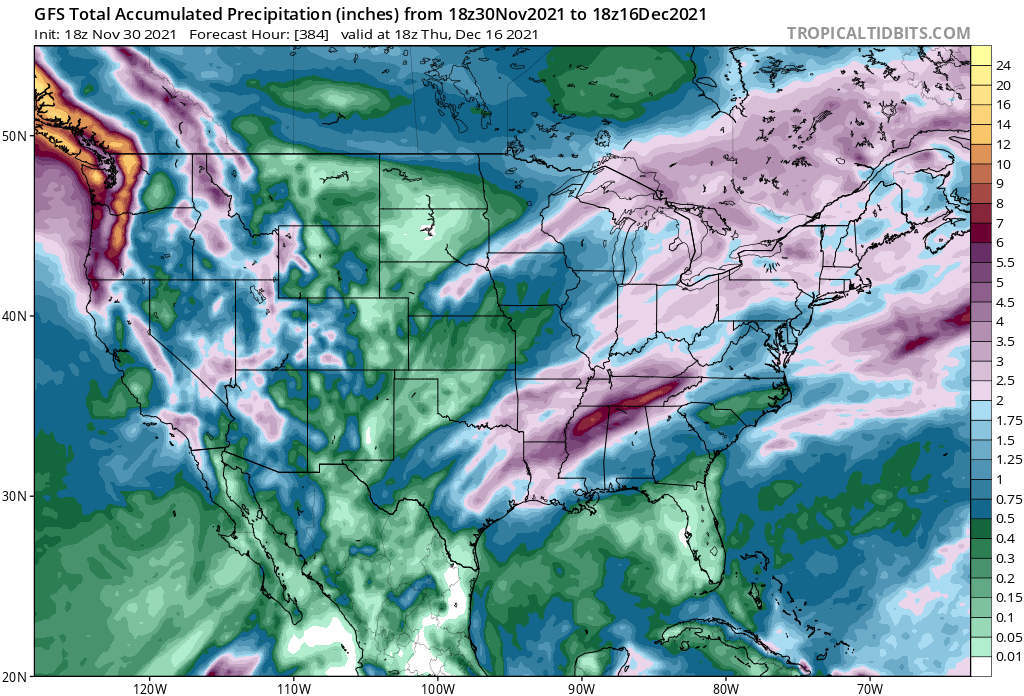
As quickly as they turned wet the weather pattern turned dry with only 2.07″ of rain falling during November, with most of that falling on just two separate days (the 12th and 22nd). While meteorological fall (Sep-Nov) is statistically the driest time of year across Northeast Georgia, most stations saw double their average in September and October but only half or less in November. And now as of the first of December, the dry streak looks to continue with the forecast over the next two weeks only calling for around 1-2″ of potential rainfall at best. Why the sudden switch? The answer may lie a few thousand miles away over the eastern Pacific.
RELATED: High fire danger
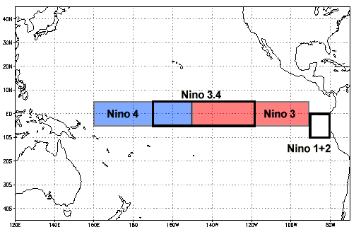
You’ve probably heard of El Niño and La Niña, but what exactly is it? These two phenomena are centered around the water temperatures over a particular region of the Pacific Ocean. The most commonly used region is known as the Niño 3.4 region, as can be seen in the image below. When water temperatures in this area are colder than average you have a La Niña, and when warmer than average an El Niño. The index we use to measure this is known as the El-Niño Southern Oscillation Index, or ENSO.
The water temperature of this region has a known effect on the overall weather pattern downstream. Stronger “episodes”, or times when they are farther above/below average, result in more concrete and predictable changes. However a weak episode can also have an effect.
Since the middle of 2020 we have been predominantly in a weak to moderate La Niña, only broken up briefly during the middle of this year when the Pacific heated up slightly. Since then, though, water temps have been going back down again and the forecast calls for a return to moderate La Niña conditions over the winter. Since the effects of these phenomena tend to be most visible over the winter I expect it to have a noticeable effect on our upcoming winter.
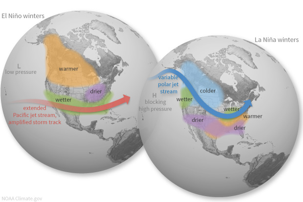
When a La Niña is in place the weather pattern tends to behave in a specific way. The jet stream over the Pacific tends to move north, resulting in a drier and warmer weather pattern across much of the Southeast US. By comparison, an El Niño tends to shift the jet stream to the south, resulting in wetter and cooler weather across the southern US and drier/warmer across the central/northern regions.
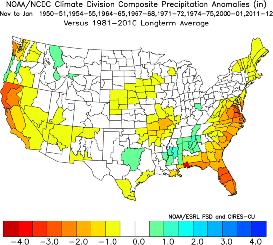
Interestingly during weak to moderate La Niñas there is often a fairly sharp cutoff from wet to dry. The map below shows the precipitation departure from normal from Nov-Jan during your “average” weak La Niña.
As you can see there is a noticeable, significant below-average region over the southeast US that includes part of Northeast Georgia. However if you go just to our west you get quickly into an area of above average. This is a very common outcome and, interestingly enough, the forecast maps over the next two weeks show a precip forecast that looks suspiciously just like the map above with a sharp cutoff from west to east.
Our last major drought that occurred in 2016-2017 occurred during a La Niña event very similar in strength to the current one, although it should be noted the pattern was shifting from a strong El Niño into a moderate La Niña which can have different effects than our current change of Niña, then average, then back to Niña transition. Last winter we also saw a moderate La Niña and, while there was less precipitation than average we were never in any real trouble of a drought. That said, we had also seen more rainfall since despite being below average both November and December 2020 was the 3rd wettest on record for much of the region.
The recent fire danger statements and wildfires in North Carolina have certainly brought some attention to this change in weather pattern. Just across the state line a burn ban is in effect until further notice for all of North Carolina, and multiple wildfires have already destroyed over 1000 acres of forest. Parts of Georgia have been officially classified as D0, or abnormally dry, by the drought monitor. While this is by no means a particularly big problem just yet, the forecast for very little rain over the coming at least two weeks will only cause these areas to get larger. In addition the emergence of this La Niña could spell trouble over the next 2-3 months since it generally results in drier than normal conditions. 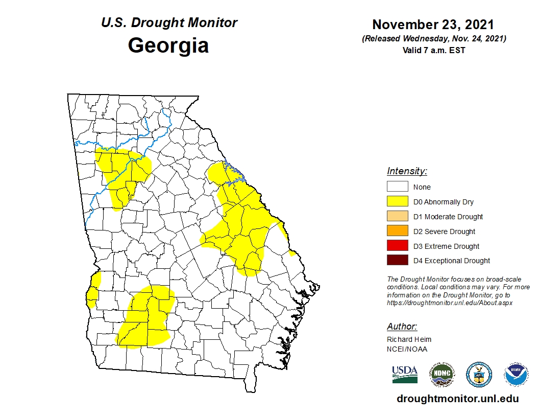
So, is La Niña to blame for our recent spell of dry weather? Most likely, but forecasting future La Niña/El Niño events is very difficult even when only trying to forecast 2-3 months in advance. If we do see a moderate La Niña develop over the winter we could easily see a weak drought develop across Northeast Georgia.
At the end of the day this just goes to show that weather across the entire planet is connected. What happens in the Pacific Ocean can/does have an effect on what goes on here in North Georgia. In the meantime be sure to be very careful if doing any outdoor burning and stay vigilant for any fire danger statements issued by the NWS.

