It’s in the forecast now. It will come and go all winter. Here’s a look at what it means.
Dear North Georgians,
Social media today is abuzz with talks of that little four letter word most meteorologists in the south dread to hear: SNOW. Earlier today an Atlanta news network along with various social media accounts threw this word out for the first time this season. The latest modeling indicates the potential for some snow to fall across parts of the region, but this storm is still 5 days away and a lot can change between now and then. We’ll talk specifics in a moment, but as we head through this winter you’ll be seeing lots of forecasts for snow from a lot of different sources. We here at Now Habersham have a history of not going overboard with predicting snow particularly far out, due to the highly unstable nature of this forecasting. As a general rule use the following guidelines for taking these forecasts seriously:
5 days (120+ hours out)- The pattern may be supportive of snowfall for parts of the region. It could also be 45 and raining or 60 and sunny. Active periods of weather have very bad forecasting reliability at this range.
4 days (96+ hours out)- Slightly higher confidence than at day 5. If models are in extremely good agreement then there’s some real potential here, but the potential for a busted forecast is still very, very high.
3 days (72+ hours out)- We can start nailing down locations most likely to see snow and throw out some ballpark accumulation guesses. Keep in mind that when you see a forecast for 1-2″ of rain in the summer (a normal forecast), that’s the equivalent of forecasting 10-20″ of snow. Snow forecasts change by 1″ for every 1/10″ of moisture available (or even 1/12-1/14″ in some cases. You can guess how easily 1/10″ can come and go.
2 days (48+ hours out)- Increasingly high confidence that snow will fall. The rain/snow boundary will probably still move by 20-40 miles or possibly more. Accumulations will be more exact but still questionable for some locations.
1 day (24+ hours out)- High confidence on snowfall, medium confidence on accumulations and locations. Around here, forecasts for snow usually still bust for a lot of folks outside the mountains even at 24 hours out. There are a million things that can go wrong to cause your particular house not to see snow. The area south of a Clarkesville->Cleveland->Dahlonega->Dawsonville line is particularly prone to busted short-range forecasts.
12 hours out- It’s probably snowing by now, and we swap to more observational forecasting. Some high resolution short-range models such as the HRRR and RAP will be used to narrow down an hourly forecast for precip type, amounts, snow banding and such.
1 day after- Some folks will have gotten snow, some folks didn’t. I promise someone is disappointed and mad, and someone is happy. That’s just how it goes in the south. I bring to Now Habersham 10+ years dealing with southern snowstorms and the public’s perception of them. I will do my best to keep you up to date on the latest changes to the forecast and try to highlight and explain all potential caveats that could cause the forecast to go from 32 and snow to 33 and rain.
Now that that’s out of the way, let’s look at this potential system next week.
Our main player is a cutoff upper level low that will move somewhere across the southeast in the Monday-Wednesday timeframe. An area of surface low pressure will develop south of this cutoff and move NE bringing rain to the area late Sunday through Monday. I’ve highlighted this ULL’s position just after midnight Monday using the newest run of the Global Forecasting System (GFS).
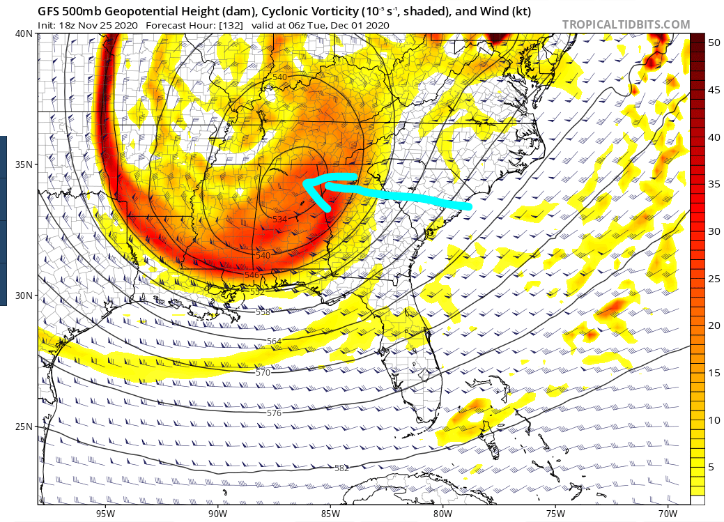
Given this placement, strong NW winds would be wrapping around the surface low bringing some moisture across the area. In addition a second, weak surface low could develop helping add a little more moisture to the equation. With this type set-up the GFS puts out the following snow forecast.
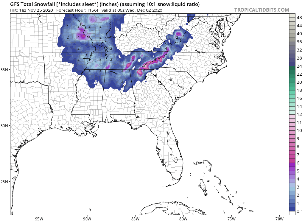
You can see it shows the higher elevations receiving a couple inches of snowfall (when accounting for melting), but with a VERY quick drop-off from NW to SE. But, keep in mind this is a low-resolution model and the snow would actually be limited to an even smaller area.
And here’s where it gets good.
Let’s step back to just 6 hours ago to the previous run of the same model. The ULL is placed in almost the same spot, but is somewhat weaker.
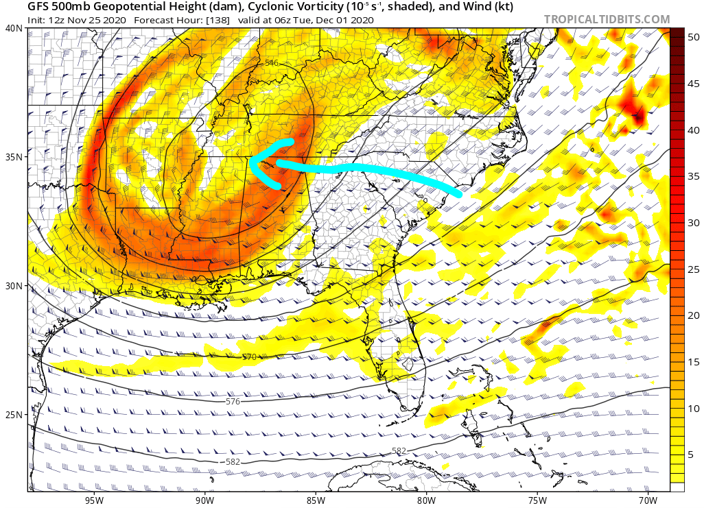
And the resulting snow accumulation forecast tells a different story entirely.
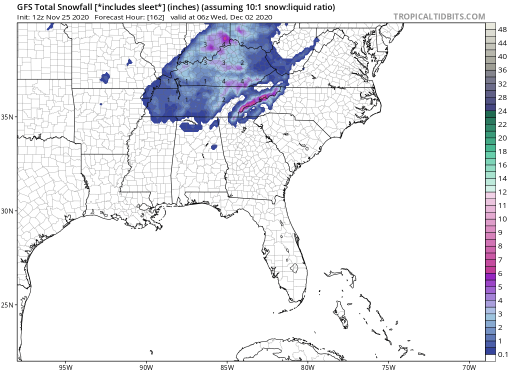
You can see the overall snowfall area is significantly smaller and barely anyone in the state sees any accumulation. If you don’t live in Blue Ridge, Ellijay, Suches or Sky Valley this solution wouldn’t give much more than some token flurries.
And that is from just one model run to the next. This model runs FOUR times every day, and there are numerous others that also run 2 or 4 times a day (the Euro, CMC, ICON, and UKMET just to name a few), all of which show a different solution every time. Small changes in position or strength of these upper atmospheric features have big implications for our sensible weather here on the ground.
Certain forecasting sites and news agencies like to pick and choose which model or model run suits their story to get the most ratings. That’s just not me. So my opinion on next Monday, you ask? WAY too early to tell, but unless something major changes we won’t be seeing any accumulating snow for 90+% of the area. Places like Sky Valley, Blue Ridge, Suches, and Ellijay that tend to squeeze a little more out of these northwest-wind-dominated flows stand the best chance, but for you folks living in Clarkesville, Cleveland, Dahlonega, Dawsonville, Gainesville, Lavonia, etc. it’s just not a set-up that looks particularly favorable. Some flurries and wind? Sure, but not a nice big snowfall.
With all that said, don’t give up hope. Remember my guidelines? This storm is still in the 4-5 day range when significant changes are still possible. In fact, with some ULL’s the forecast can change drastically within the last day.
So keep your fingers crossed, your sleds nearby, and stay with Now Habersham for accurate, reasonable, not-ratings-driven forecasts.
Sincerely,
Tyler Penland
Lead Forecaster
Now Habersham


