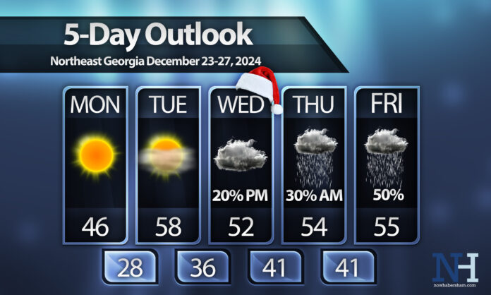
A quick warm up will occur this week as we head towards Christmas day with an unsettled end to the week.
We’ll have one more quite chilly day on Monday with highs only reaching into the 40s. Overnight Monday will be our last trip below freezing for the week with widespread frost expected Tuesday morning. Temperatures will soar quickly on Tuesday as high pressure builds in from the west and turns our winds to the south. The warmer spots will reach the low-60s on Christmas Eve with mid/upper-50s for the rest of the region.
Santa looks to have a dry visit overnight with the forecast remaining dry for at least the first half of Christmas Day. Unfortunately, that high pressure that heats us up on Tuesday will slide to the northeast on Christmas Day ushering in a wedge of cooler air across the region. This will also result in some isolated showers during the evening with a bit more widespread activity likely overnight and into the first half of Thursday.
We should turn dry Thursday afternoon before another weather system quickly approaches form the east spreading more moisture into the region for Friday.
Have a great week and stay tuned for continued updates to the Christmas Eve and Christmas Day forecast!


