This week we’re throwing it back to a post from August 1, 2015. I had recently made my first visit to the highest point east of the Rockies and was excited to share this place with all my fellow North Georgians. Since then I have camped and hiked all over this peak and ones surrounding it, including one snow summit in early 2020. It will always remain one of my favorite places in the southeast and I hope you get the chance to visit one day.
At any rate, here’s Mt. Mitchell.
Located north of Asheville, NC in the heart of the Black Mountain Range, Mt. Mitchell claims it’s stake as the highest point east of the Mississippi River. Standing tall at 6,684ft (1900ft higher than Brasstown Bald), it harbors a different kind of climate than anywhere else in the Appalachians. The highest temperature ever recorded atop Mitchell is a mere 81º and the lowest all time is -34º. It rains just over 6ft per year on average, with 90.8″ of snow. It rains 42% of the days in a year and is cloudy or foggy more often than that. This fairly cold/wet climate allows a very rare spruce/fir forest to thrive. If you travel to Mitchell, you will be stepping into forests more like those of southeastern Canada than the southeast United States.
The mountain is accessed via the Blue Ridge Parkway from Asheville (plenty of signs) and is part of the Mount Mitchell State Park. There are several high-elevation hiking trails through the fir and spruce forests, but the primary trail is the 1/4 mile paved trail from the parking area to the summit of Mitchell. An observation deck awaits at the top, and the views are incredible.
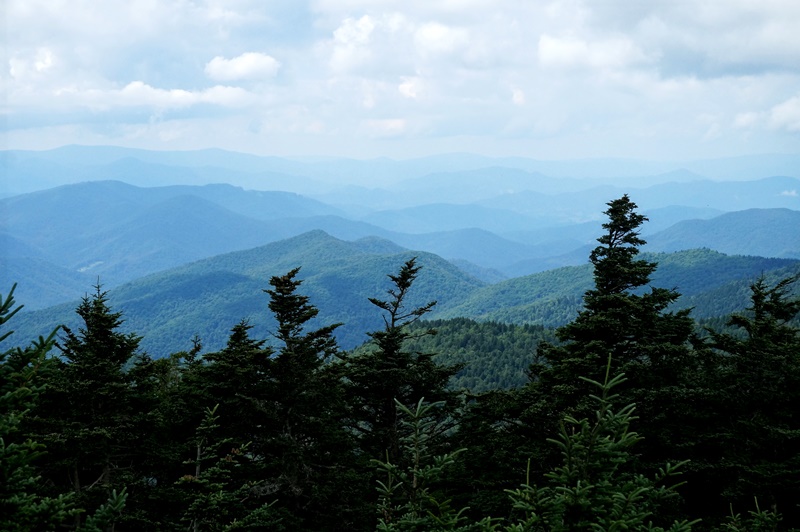
View from the observation deck looking north
The short, paved trail from the parking lot to the observation deck
A view of the abundant Frasier firs near the summit
Frasier Firs (of Christmas tree fame) grow in abundance near the top, and are nearly the only tree type in many areas.
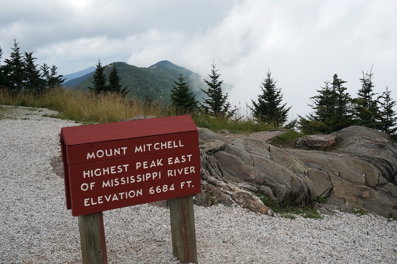
The elevation sign on the summit, with Mt. Craig and Big Tom in the background
Also located within the Black Mountains lie 5 other peaks which all fall into the top 10 highest on the east coast. I have summited Mount Craig (2nd highest, approximately 1 mile away) and Big Tom, which are both accessed via the very strenuous Deep Gap Trail. This is one of the most amazing trails I have ever been on, however I recommend it only for those who are very physically fit as you have to climb over many boulders, some of which are quite slick, and there are many very steep sections. The moss covered logs and thick stands of spruce/fir are amazing to see, and unlike any other forest in the 2000+ miles of the Appalachians.
Deep Gap Trail
The View from the summit of Mt Craig
Flowers growing between the boulders
Overall, Mt. Mitchell is one of the most incredible places I have ever visited, and is definitely worth a visit if you are ever near Asheville. Craggy Gardens (which you’ll see soon enough) is located just a few miles away and of course the Blue Ridge Parkway has a ton of interesting hikes/overlooks.
One of the major problems these high elevation forests face is habitat destruction from humans. When you are there, stay on marked trails and don’t litter. The rare plants and animals that call this place home are extremely sensitive to changes in their environment, and a single footstep can cause irreversible damage to some. In addition, if you ever visit any areas where spruce trees grow, notice the number that are dead. This is due almost exclusively to acid rain, which over the years killed the vast majority living atop places like Clingman’s Dome and Mitchell. These places are beautiful and rare, so please use caution when visiting them.
As a bit of an elevation junkie, this hike was on the top of my bucket list and I was glad to complete it earlier this spring, though the weather conditions on my first trip to the top were less than optimal (one of the more than 50% of cloudy days, unfortunately).
For more information, you can visit the state park’s page here.
I’ll be back with more soon.
See you on the road…..~TW


