I remember sitting in class at the University of North Georgia on the morning of April 27, 2011.
I couldn’t concentrate on the schoolwork. My mind raced with thoughts of the weather briefings and models I had been reading for the previous days. I was still a budding young forecaster then, and while this wasn’t my first go around with forecasting tornadoes, it was certainly the biggest risk I had ever seen. In fact, it was the biggest risk many had ever seen. Not since 1974 had the southeastern U.S. been under the gun as badly as it was on that fateful day. My love for the weather was no secret to my professors, and as I sat in Dr. Robert Fuller’s class, I recall him asking me what I thought was going to happen. My reply? “Nothing good.” Little did I know how right that would be.
The day started early for forecasters as a strong line of storms pushed east across Alabama and much of Tennessee. This line would stay mostly below severe limits as it moved across the far northern parts of our state, but it did considerable damage over much of Alabama. The trend of Alabama taking the brunt would continue through the rest of the day.
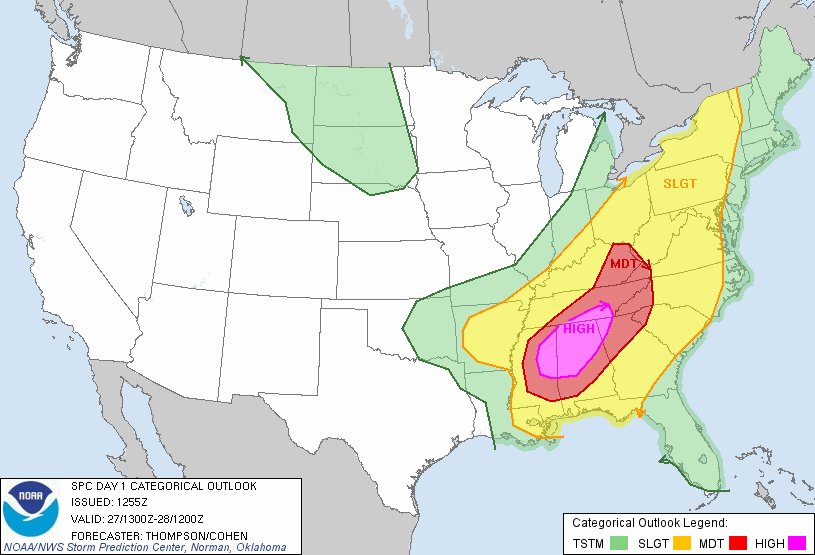
The Storm Prediction center started the morning off with all of North Georgia under a moderate risk (level 4/5) of severe weather. This outlook from 10 a.m. highlights the areas that would later get raked by numerous supercells.
By mid-afternoon, a swarm of EF-4 and EF-5 tornadoes were ripping across most of eastern Mississippi, Alabama, and Southern Tennessee. A record-shattering 216 tornadoes would be reported through the day, with the outbreak in total producing 360 tornadoes over its 4-day course. Total fatalities would end at 348 with thousands of injuries and over $10 billion in damages.
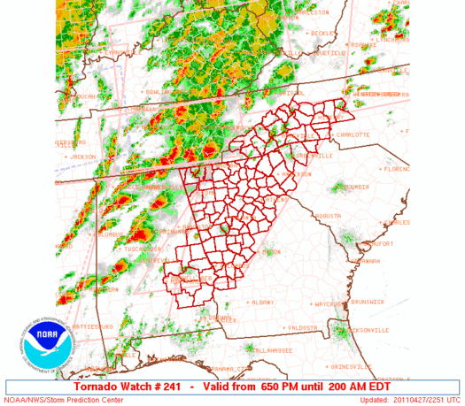
For North Georgia, a Particularly Dangerous Situation (PDS) tornado watch was issued at 6:50 p.m. Ten years later, it remains the last PDS watch issued for this area.
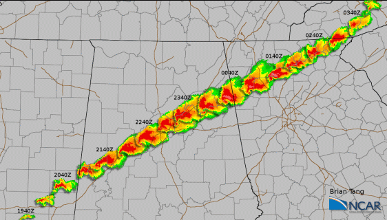
The storm that would bring destruction to Northeast Georgia actually started during the early afternoon over eastern Mississippi. This monstrous supercell produced numerous deadly tornadoes along its over 7 hours, 350-mile long path. This included the Tuscaloosa and Pleasant Grove tornadoes in Alabama that killed 64 people and were rated high-end EF-4s. By late evening, this storm was beginning to track into North Georgia and can be seen denoted as “supercell #2” in the graphic below.
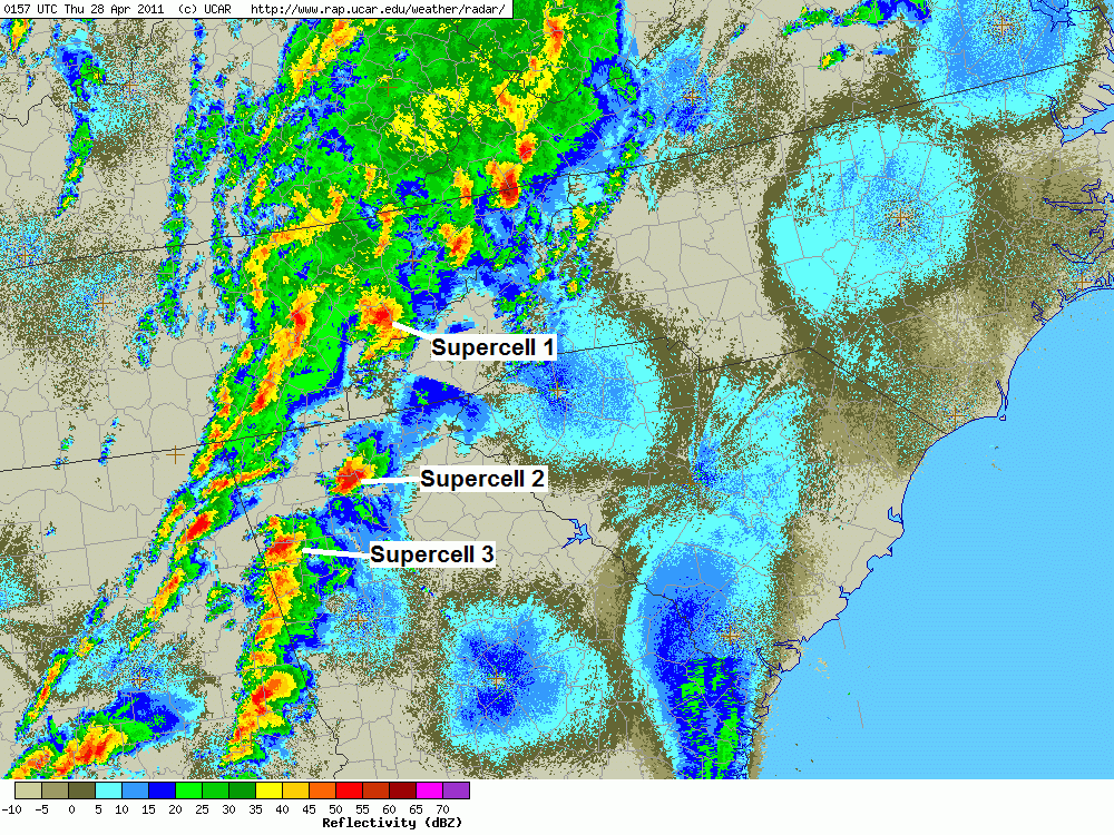
As the storm started into Northeast Georgia, it ran along/just north of the highest peaks, almost seeming to be steered by these higher elevation peaks.

A tornado touched down over remote North Lumpkin County at 10:20 p.m. The tornado would then move across northern White County and extreme NW Habersham County. No homes were damaged in Lumpkin and White, but extensive tree damage occurred. In some areas, particularly in the forested sections of White County, it is still very apparent where the tornado came through. The true strength of the tornado is unknown due to the lack of affected structures, but the NWS rated it as an EF2 for much of this time. One of the more impressive things about this particular tornado is that it managed to stay on the ground over some significant elevation changes. Oftentimes large elevation changes can cause circulations to die out, but in this case, the tornado handled changes of 2000ft with no problem.
The tornado would then move into Rabun County, where it crossed Lake Burton. Extensive damage to numerous homes was reported, and I’ve included the NWS assessment of the tornado as well as a few photos from during this time below.
"THE TORNADO STARTED AT LAKE BURTON CAUSING EF3 DAMAGE ACROSS THE
NORTHERN PORTION OF THE LAKE (POSSIBLY HIGHER PENDING WEATHER
SERVICE HEADQUARTERS EVALUATION). THE TORNADO STARTED NEAR THE
LAPRADES MARINA OFF OF HIGHWAY 197 AROUND 11 PM. SHORTLY AFTER
TOUCHDOWN THE TORNADO HIT THE WILDCAT VOLUNTEER FIRE DEPARTMENT AND
THE OLD FIRE HOUSE BUILDING...BOTH BUILDINGS WERE TOTALLY DESTROYED.
THE TORNADO TRACKED ACROSS MOCCASIN CREEK AND INTENSIFIED
SIGNIFICANTLY. THE DAMAGE PATH ALONG MOCCASIN CREEK WAS A HALF MILE
WIDE...TWO TO THREE WELL CONSTRUCTED HOMES WERE TOTALLY DESTROYED.
ONE LARGE HOME WAS TRANSPORTED FROM IT/S SLAB FOUNDATION INTO THE
LAKE. THE TORNADO CONTINUED ACROSS THE MOCCASIN CREEK PENINSULA TO
THE BURTON ISLAND TIMPSON CREEK ROAD AREA...THEN TRACKED DOWN THE
NORTH SHORE OF THE LAKE PARALLEL TO MEETING HOUSE MOUNTAIN ROAD.
FOUR TO FIVE RESIDENCES WERE COMPLETELY DESTROYED WITH MULTIPLE
HOMES WITH MAJOR DAMAGE TO EXTERIOR WALLS. THE TORNADO MOVED JUST
NORTH OF THE ANCHORAGE MARINA NEAR HIGHWAY 76 AND CONTINUED UP A
RIDGELINE NORTHEAST OF THE LAKE."
NWS Greenville
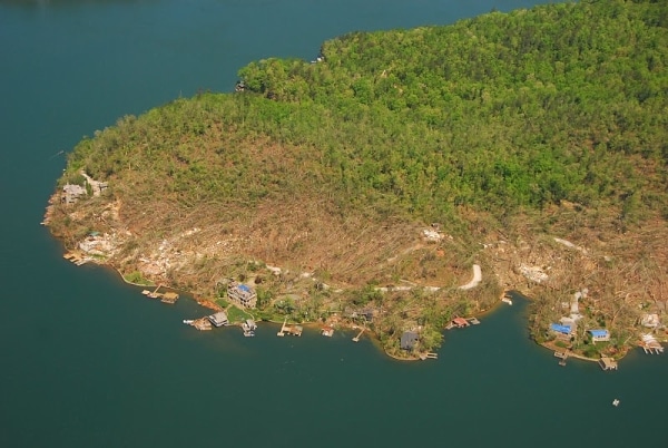
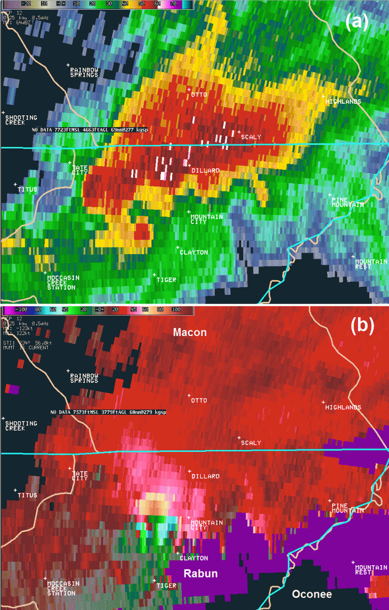
The tornado killed Atlanta businessman Earl Patton when it ripped apart his home on Lake Burton.
Ultimately, the tornado would weaken, then briefly intensify outside Mountain City before running into the highest peaks of NE Rabun and dissipating.
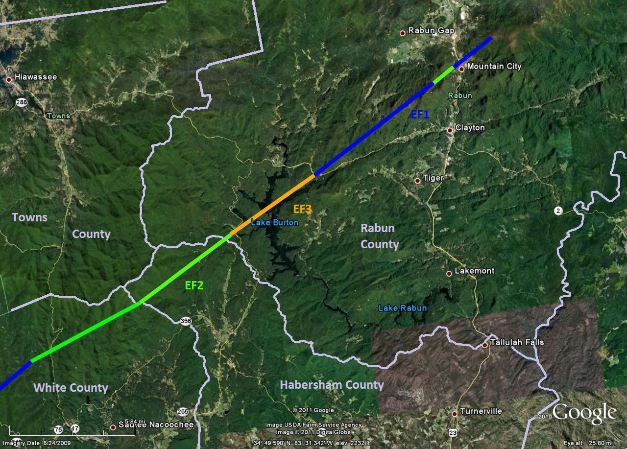
In total, the tornado was on the ground for 48 minutes. The supercell that produced it would finally die out over SW North Carolina as it impacted the 6000+ foot peaks of the Balsams.
Another supercell storm would cross nearly the same path just an hour and a half later, but it did not produce a tornado in the state and only dropped one small EF0 in SW NC.
In the end, this storm and outbreak would go down in the record books. It’s one that neither I nor any other forecaster that witnessed it will ever forget.
Rebuild. Revive. Remember
4.27.11


